We remain fully operational. Our teams are working around the clock to ensure your deliveries continue safely.

Descargar la aplicación


Servicios al cliente
Sobre nosotros
Copyright © 2025 Desertcart Holdings Limited
Descargar la aplicación


Buy anything from 5,000+ international stores. One checkout price. No surprise fees. Join 2M+ shoppers on Desertcart.
Desertcart purchases this item on your behalf and handles shipping, customs, and support to Argentina.
🗺️ Elevate your strategy with the map that means business!
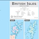
This Large British Isles Administrative Map by Maps International measures a commanding 84.1 x 118.9 cm and features a front sheet lamination for a durable, writable, and wipeable surface. Expertly packaged to arrive crease-free, it highlights UK postcodes, towns, and counties with precision, making it an essential tool for professionals, educators, and planners seeking clarity and flexibility in their workspace.


| ASIN | B0B82MN4N8 |
| Best Sellers Rank | 38,336 in Stationery & Office Supplies ( See Top 100 in Stationery & Office Supplies ) 41 in Classroom Maps |
| Brand | Maps International |
| Colour | Front Sheet Laminated 84.1 x 118.9 cm |
| Customer Reviews | 4.7 4.7 out of 5 stars (36) |
| Date First Available | 29 July 2022 |
| Item Weight | 440 g |
| Manufacturer | Maps International |
| Manufacturer Part Number | UK00263_L_LAMIN |
| Package Dimensions | 90 x 5.5 x 5.5 cm; 440 g |
| Sheet Size | 84.1 x 118.9 cm |
L**D
Great quality map
Fabulous map very happy with it. Made from Good quality paper, perfect for what I need it for. Clearly shows main towns, cities and counties. Exactly what I needed Thankyou
C**Y
Chevk the size.
Excellent.
D**N
Good quality.
My son is a season ticket holder for his football club and he goes all over the country to matches. He uses this map as a record of places he's been to. Different coloured pins for different leagues, England games, or Premiership clubs. It's large and readable.
A**R
Quality item
Quality item
M**S
Great!
Love this, big and laminated just perfect
K**.
Decent size with clear to see locations.
Got this for my hubby's birthday. He's in his element putting the map stickers on all the places we've stayed over in our campervan. We've currently covered about 85% of UK coastline.
T**N
Brilliant
Very detailed town map of the UK
L**E
Very detailed
This is a great map for having on display. It is really detailed, showing towns, cities and the boundaries of counties too. It’s great to help with planning a trip or just to swat up on your geography knowledge. It is laminated so you can use board markers to write on it and then wipe them off. For me a downside is the size, it is huge! So finding somewhere to put it up is tricky. However, for others that may be a plus, because it makes it very clear and easy to read and it makes a great display.
Trustpilot
Hace 1 mes
Hace 1 mes